What You Should Know About the NASA-India NISAR Satellite Launch
- NASA and ISRO launched NISAR on July 30, 2025, to observe the Earth’s surface changes in very high detail.
- This mission marks a giant step in the path of international scientific collaboration, particularly in terms of climate and natural disaster tracking.
When NASA Met ISRO
NASA (US) and ISRO (India), two of the world’s leading space agencies, joined hands to build and launch NISAR—short for NASA-ISRO Synthetic Aperture Radar. The partnership began with an agreement signed back in 2014. NASA, known for the Apollo moon landings and Mars rovers, and ISRO, the agency behind successful lunar and Mars missions on tight budgets, combined resources for this global Earth observation mission.
What Is the NISAR Satellite Mission?
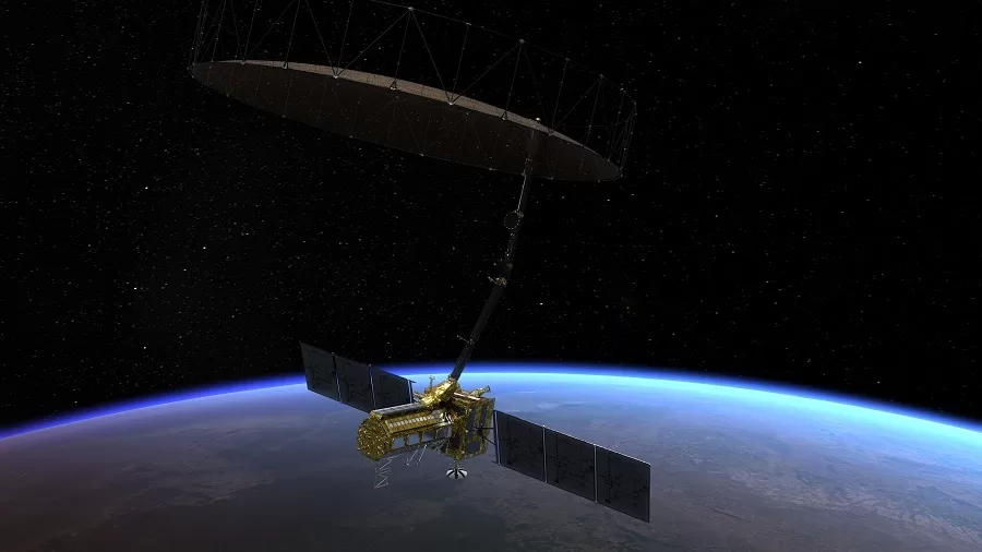
The NISAR satellite mission has been set up for precise Earth observation by radar. It will observe and measure surface changes on the Earth for satellite-based climatic information and environmental risk analyses. This method employs dual-frequency radar imaging amid weather conditions and time of day with phenomenal accuracy. The satellite consists of L-band radar from NASA and the ISRO S-band radar. The presence of two-band radars allows the satellite to detect movements of almost one centimetre.
Mission Overview: Global Earth Observation at Scale
NISAR was launched on July 30, 2025, from the Satish Dhawan Space Centre in Sriharikota, India, using ISRO’s GSLV-F16 rocket. With 747 kilometres above Earth in a sun-synchronous polar orbit, it can cover almost the entire surface of the planet in 12 days. The satellite weighs about 2,392 kilograms, and it is meant to operate for no less than three years. Having a joint mission cost of roughly $1.5 billion, it ranks as a very high-value NASA-India space collaboration. NASA sponsored close to $1.2 billion, and ISRO came with an estimated $90 million in funding.
What Will the Satellite Monitor?
The Earth monitoring radar on board NISAR will track environmental and geological changes across continents. It can monitor fault lines and earthquakes, detect ice sheet melting in Greenland and Antarctica, observe shifting coastlines and urban infrastructure, and analyse vegetation and farmland transformations. These insights contribute to space technology for Earth observation and help address critical climate-related issues.
Why This Satellite-Based Climate Data Matters Now
Changing weather patterns, happening too rapidly, with increased rates of disaster, rising seas, and so on, demand urgent interventions from space-based climate data. Radar data from NISAR would help glaciologists detect early signs of glaciers retreating, sea level rising, or land sinking, as well as the loss of groundwater. This gives policymakers, researchers, and communities real-time information with which to work, improving the global analytics of environmental risk.
How the Synthetic Aperture Radar (SAR) Works
NISAR relies on Synthetic Aperture Radar (SAR), a powerful remote sensing method that transmits microwave signals to Earth’s surface and records the reflections. Unlike optical systems, SAR works under cloud cover and at night, making it more consistent. The NASA-provided L-band radar penetrates vegetation and topsoil, while the ISRO-provided S-band radar captures more surface-level detail. Together, they enable consistent global Earth observation regardless of weather conditions.
Building and Launching the ISRO-NASA Radar Partnership
NASA and ISRO began building NISAR following their 2014 agreement. Most systems were completed by 2023, although final integration was delayed due to thermal concerns with the radar antenna. By mid-2025, NASA had shipped the completed satellite components from the Jet Propulsion Laboratory in California to India. On 30 July 2025, the satellite found its way to outer space, one of the many testimonies to the strength of the ISRO-NASA radar collaboration.
What Comes Next for the NISAR Satellite Mission?
NISAR enters a 90-day checkout period following launch to prove system performance and to deploy its large antenna. Full science operations shall be commenced by late October 2025. The data collected will be shared publicly to facilitate real-time monitoring of various earthly dynamic systems and support global environmental research.
A Model NASA-India Space Collaboration
This is an example of a successful NASA-India space collaboration. While NASA had furnished the radar payloads and the data systems, as well as the GPS equipment, ISRO, on its side, has provided satellite structure, propulsion systems, and launch services. Both have agreed that the data from the shared NISAR satellite mission will be kept open-access for usage by researchers, governments, and educational institutions across the globe.
Who Benefits From NISAR’s Global Earth Observation?
Disaster responders, environmental planners, climate scientists, and urban planners will find this new NISAR satellite mission to be of supreme importance. Tracking landslides and floods, or simply planning for resilient infrastructure, the data from the satellite can aid in all such activities. The highest-quality satellite-based climate data system will also be available to universities and NGOs.
Long-Term Impact on Environmental Risk Analytics
As climate change accelerates, tools like the NISAR satellite mission are critical. Its Earth-monitoring radar will help identify vulnerable areas, support decision-making, and contribute to long-term sustainability planning. Beyond its technical achievements, NISAR is a case study in how international partnerships can deliver real-world value through global Earth observation.